by
Halide Nur Dursun | Jul 09, 2025
Recent findings from our Seismology-Seismotectonic-Geodynmaics research group introduces new data on Ancient Oceanic Remnants Discovered Beneath Anatolia.
A new discovery out from a seismic tomography experiment performed by Dr. Judith M. Confal, Prof. Dr. Tuncay Taymaz and Assoc. Prof. Dr. Tuna Eken from the Department of Geological Engineering has revealed evidence of ancient oceanic remnants deep beneath northern Anatolia. Published in the prestigious journal Earth and Planetary Science Letters (see Confal et al., 2025 for more details), the study identifies preserved fragments of the long-vanished Tethys Ocean plate, offering new insights into the region’s deep geodynamic history.
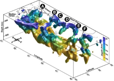
During this research, high-resolution seismic P-wave tomography has been utilized to uncover five finger-like high-velocity anomalies located 80–250 kilometers beneath the Earth’s surface. These anomalies likely represent remnants of the Paleo-Tethys and Neo-Tethys oceans once separating the ancient supercontinents Gondwana and Laurasia.
This discovery rewrites regional geological understanding and adds a new layer of complexity to the tectonic history of Anatolia. Over millions of years, the region has been shaped by multiple subduction episodes and continental collisions. The identified structures may be buoyant remnants of the Neo-Tethys slab that have remained shallow due to underplating since the early Cenozoic era.
The study also suggests that the unusual geometry and spatial arrangement of these structures could be associated with ongoing mantle flow and recent lithospheric foundering processes, potentially driven by continental convergence.
Despite significant progress in understanding Anatolia's tectonic evolution over the last 30 million years, deciphering older plate movements and lithosphere–asthenosphere interactions remains a scientific challenge. This new research provides a rare window into those earlier dynamics and holds particular importance in light of the region’s ongoing seismic hazards, including those along the North Anatolian Fault Zone.
This landmark discovery not only enriches the field of Earth sciences but also provides valuable data for seismic hazard assessment and future geodynamic modeling across the Eastern Mediterranean.
Relevant Citation: “Confal, J.M., Taymaz, T., Eken, T., Bezada, M.J., Faccenda, M. (2025). Remnant Tethyan Slab Fragments Beneath Northern Türkiye. EPSL – Earth and Planetary Science Letters, Vol. 664, 119458, https://doi.org/10.1016/j.epsl.2025.119458”
More information about this work can be seen from the following web link:
https://www.sciencedirect.com/science/article/pii/S0012821X25002572#ec0020

Figure: 3D high velocity perturbation isosurface (>2.5%) beneath Northern Anatolia and Eastern Greece. The color scale of the isosurface is depth-dependent and uses a logarithmic scale. Anomalies A, B, C, D, E, and F are the same as those highlighted in Fig. 2. Abbreviations: AS, Aegean Slab; BS: Bitlis Slab; WCS, Western Cyprian Slab, and ECS, Eastern Cyprian Slab. The figure is taken from Confal et al., 2025